Leap Day Blizzard of 2024
Storm Summary
Due to road and weather conditions on Mount Rose, we will not be doing a media day this month. We plan to hold the last one of the season in early April.
Contact: Jeff Anderson, jeff.anderson@usda.gov, 775-224-3484
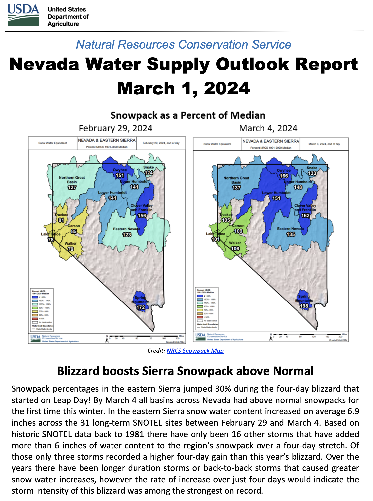
The snowpack in the eastern Sierra is above normal for the first time this winter thanks to the blizzard that started on Leap Day!
On January 1 the snowpack was 44% of median snow in the eastern Sierra, ranking 6th lowest for the date since 1981. As of March 4, snowpack percentages are 101% of median in the Lake Tahoe basin, 105% in the Truckee Basin, 106% in the Walker Basin and 109% in the Carson Basin based on data from multiple SNOTEL weather stations in each basin. Snowpack percentages compare the amount of water locked in this year’s snow to the 30-year period between 1991-2020.
Snowpack percentages in the eastern Sierra basins jumped 30% during the four-day long blizzard. Snow water content increased on average 6.9 inches across the 31 long-term SNOTEL sites in the eastern Sierra between February 29 and March 3. Based on historic SNOTEL data back to 1981, only three storms recorded a higher four-day gain than this year’s blizzard. Over the years there have certainly been longer duration events or back-to-back storms that caused far greater snow water increases, however the rate of increase over just four days would indicate the storm intensity for this blizzard was among the strongest on record.
Snow water amounts typically peak in late March or early April. As of March 4, the Carson and Walker basin’s snowpack have already reached their normal peak amounts. The Lake Tahoe and Truckee Basins are close but still need another storm or two to reach their normal peaks. Snow percentages across the rest of Nevada are currently 133-198% of median and all areas have already exceeded spring-time peak amounts.
The March 1, 2024, NRCS Water Supply Outlook Report will be published by the end of this week. This report includes streamflow forecasts for this spring’s runoff. To subscribe to the report and to track current snowpack conditions across the eastern Sierra and the state of Nevada visit: https://www.nrcs.usda.gov/nevada/snow-survey.
This month’s report and streamflow forecasts are available on the Nevada Snow Survey webpage: nrcs.usda.gov/nevada/snow-survey
NEW SUBSCRIBERS:
Watch this overview video about how the Nevada NRCS snow program can serve you: youtu.be/gWm5TeASLY8
The latest NRCS Nevada Water Supply
Outlook Report is now available online
https://www.wcc.nrcs.usda.gov/ftpref/support/states/NV/wsor/NV-WSOR-2024-3.pdf
Read the background information on page two of the report and other help information located in the appendix which discusses how the NRCS measures the snowpack, how to interpret the streamflow forecast chart, and details about various streamflow adjustments.