 Background: Repeat photography can qualitatively document vegetation changes at large scales.
For those involved in discussions about the “condition” or “state” of rangelands today, there is great benefit for understanding what the composition and structure of those rangelands was shortly after settlement: an era of unmanaged grazing that exemplified the tragedy of the commons. The Forest Service’s Santa Rosa Ranger District (hereafter District), in north-central Humboldt County, is one area with a photographic history of over 100 years.
The District has about 288,000 acres in active grazing allotments. Willow laced small streams, wet and dry meadows, and stands of aspen are common, and interspaced with mountain big sagebrush, mountain brush and low sagebrush plant communities.
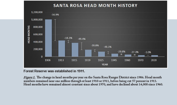
Livestock grazing began in the 1860’s, but use was poorly documented until 1906-1910 era, when 150,000 to 200,000 head of sheep, 16,000 head of cattle, and about 1,500 domestic horses grazed the District each year (Figure 1).
This equated to about one million head months per year, or about 5.4 months per head, per year, on the District. This resulted in continuous grazing from when plant growth began each spring until the stock moved to other areas in the fall.
In 1912, the District implemented a permit system. Livestock numbers declined from about 200,000 to 81,000 head, mostly through elimination of the nomadic sheep herds, but also 2,500 fewer cattle. Even with dramatically fewer numbers, livestock grazing remained season-long until at least the late 1940’s. The District had only three or four grazing allotments, with no internal pastures, and no infrastructure to adequately implement rotation grazing systems. Sheep permits were converted to cattle or being phased out.
The implementation of rotational grazing systems began in the late 1940’s, as did the construction of associated infrastructure (fences, water developments, etc.). Full implementation and enforcement of rotation systems across the entire District probably did not occur until the 1960-1970 era, with periodic adjustments since then. The last sheep permit ended in 1963. Deer populations from the 1950s into the 1980s were much larger than today,
Today, livestock grazing occurs in 12 active allotments with 58 pastures. Each allotment follows either a rest-rotation or deferred rotation system, with two to seven pasture per allotment. Turn-on dates range from mid-April to mid-June, and off-dates from late August to the end of September.
The current permits total about 10,542 head of cattle and a couple dozen domestic horses. This equates to about 36,500 permitted head months or 3.6 percent of those in 1910. Each head now spends and average of 3.6 months on the District, which is 65% of the annual duration in 1910. Since 1970, livestock numbers have changed little, and the District has built several large riparian pastures since 1990. District wide management changes from 1912 through the 1960’s have given way to periodic adjustments that typically address site specific issues.
Methods and Work to Date: In about 2015 the USFS provided Brad Schultz, Extension Educator in Winnemucca, NV thousands of historical photos from the District. Some were from the 1910-1930s era, but most from the 1950’ through the early 1990’s. Those with distinct topographic features to facilitate their relocation were extracted for potential use.
Repeat photography works best when the past and current photos occur at the same growth stage, time of day, and sunlight. Since 2015 smoke-filled skies often have precluded replicating the conditions of the original photos. In 2020 and 2021, repeat photos occurred whenever skies were clear of smoke, following the concept that any current photo is more useful than no photo, for understanding changes in rangeland landscapes.
For all repeat photos, topographic features were realigned to the extent possible. The photo-point of the new photo was recorded with a handheld GPS unit, to facilitate future efforts of photo documentation. To date, about 150 repeat photos have been obtained, but space only allows presentation of a few in this article.
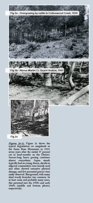
Results and Discussion: The historic photos occur across a suite of vegetation types ranging from upland shrub-grass range, to aspen stands, to wet and dry meadows. Pictures from the 1910 era show widespread severe degradation (Photos a in Figures 2-4), which often persisted into the 1960’s and later (Figure 2b, 2c, 5a, and 6a).
The photo record clearly demonstrates that only cutting livestock numbers was not a viable solution to the historic grazing problems on the District. Head months on the District in 1945 and later were only five percent or less of those in 1910, but severely degraded range persisted for several decades or more. Many stands of aspen only began to establish an understory in the early 1960s (Figures 2b and 2c).
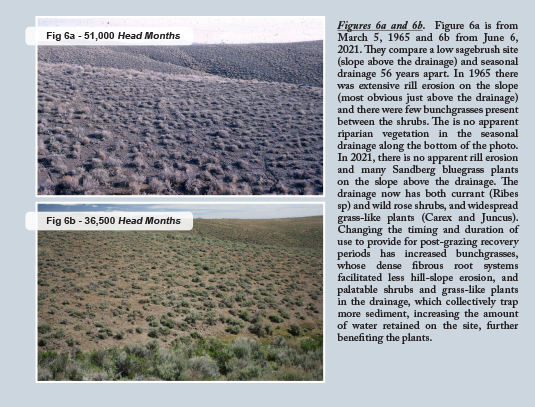
Figures 3-8 are a representative sample of the photos taken to date. They show the degree of vegetation or soil changes across time, which ranges from 45 to 104 years between photos. The caption for each pair of photos provides an interpretation of their comparison.
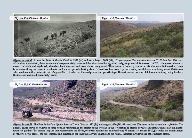
The initial large reduction in livestock numbers set the stage for recovery of the vegetation and soils, but landscape wide recovery of desired perennial herbaceous species, aspen stands and riparian willows was slow (Figures 5-7). Slow recovery occurred, at least in part, because grazing of the forage plants remained largely season-long until at least the late 1940’s, and possibly even into the 1950s and 1960s.
Construction of the infrastructure needed for effective rotation systems started in the 1940s but took years to build out, and in some respects is still inadequate. Accompanying season-long use, was heavy forage utilization and inadequate recovery periods for grazed plants. This prevented desired species from developing sufficient leaf area to replenish their energy reserves and maintain large root systems that reduce soil erosion (Figure 6, next pg).
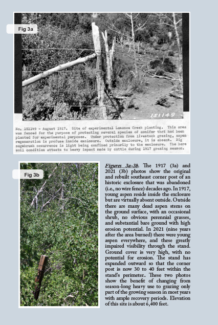
Increasing the number of pastures, developing water, and implementing rotational grazing systems benefited the vegetation across all plant communities (Figures 3-8). Eventually managed grazing allowed the forage plants across all pastures to complete their annual growth cycle – defined as no grazing before completing seed production – during at least one year (and often two or more years) of the rotation cycle.
Pastures grazed with deferred rotation systems are grazed every year, but grazing in one or more pastures occurs only after growth, energy production and energy storage have occurred for the year. Across the rotation cycle (2 to 5+ years depending on the allotment), all plants receive some exposure to grazing during the growth stages they are least resistant to grazing, but also non-use during those periods in other years. Generally, there are lengthy growing periods between grazing events so plants have time to recover.
Cutting livestock numbers does little to improve the outcomes of grazing if the time of use, duration of use, and intensity of use do not allow the plant time to produce and store sufficient energy to remain alive during dormant periods and renew growth the following year. Adequate energy production also allows the perennial herbaceous plants to produce large, dense root systems capable of capturing enough water and nutrients to provide for abundant leaf and stem growth, the basis of abundant forage.
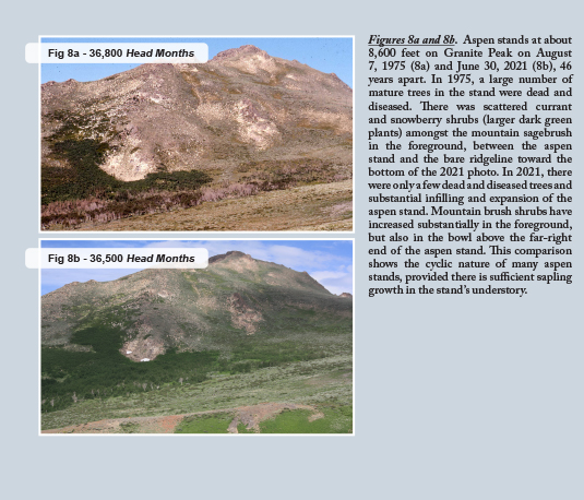
The aspen stand in Figure 8a and 8b strongly indicates the cyclic nature of these communities. Large mature trees periodically die-off, even at the comparatively low stock numbers of the 1970’s (compared to 1910). When properly grazed, the stands maintain young shoots in their understory, and these shoots grow into canopy gaps that emerge upon the death of large established trees. Despite substantial improvement rangeland landscapes across much of the District, problems persist. Typically, they are site-specific, not landscape wide issues. Numerous water troughs still remain on some meadows, and those meadows will remain over used and below their potential until the troughs are moved off site. Other troughs have fallen into disrepair and if restored (and sometimes moved) would improve livestock distribution. Also, stock ponds built decades ago on seasonal or ephemeral streams to provide stock water have filled with sediment and store little or no water. An important step for further improvement of grazing management and rangeland vegetation on the District is identifying dysfunctional infrastructure and fixing those problems.
The photo history of the District informs today’s land managers about the extreme rangeland degradation historically present at the District’s creation. Most of us know overgrazing was common and detrimental, but few probably fully understand just how poor range conditions were, landscape wide. Nor do many fully understand, nor appreciate, the magnitude of positive changes that have occurred once managed grazing controlled the timing, duration, and intensity of use, sufficient to allow perennial plants to remain vigorous and robust, both above and below ground.
by Brad Schultz, Extension Educator, University of Nevada Cooperative Extension, Winnemucca, NV