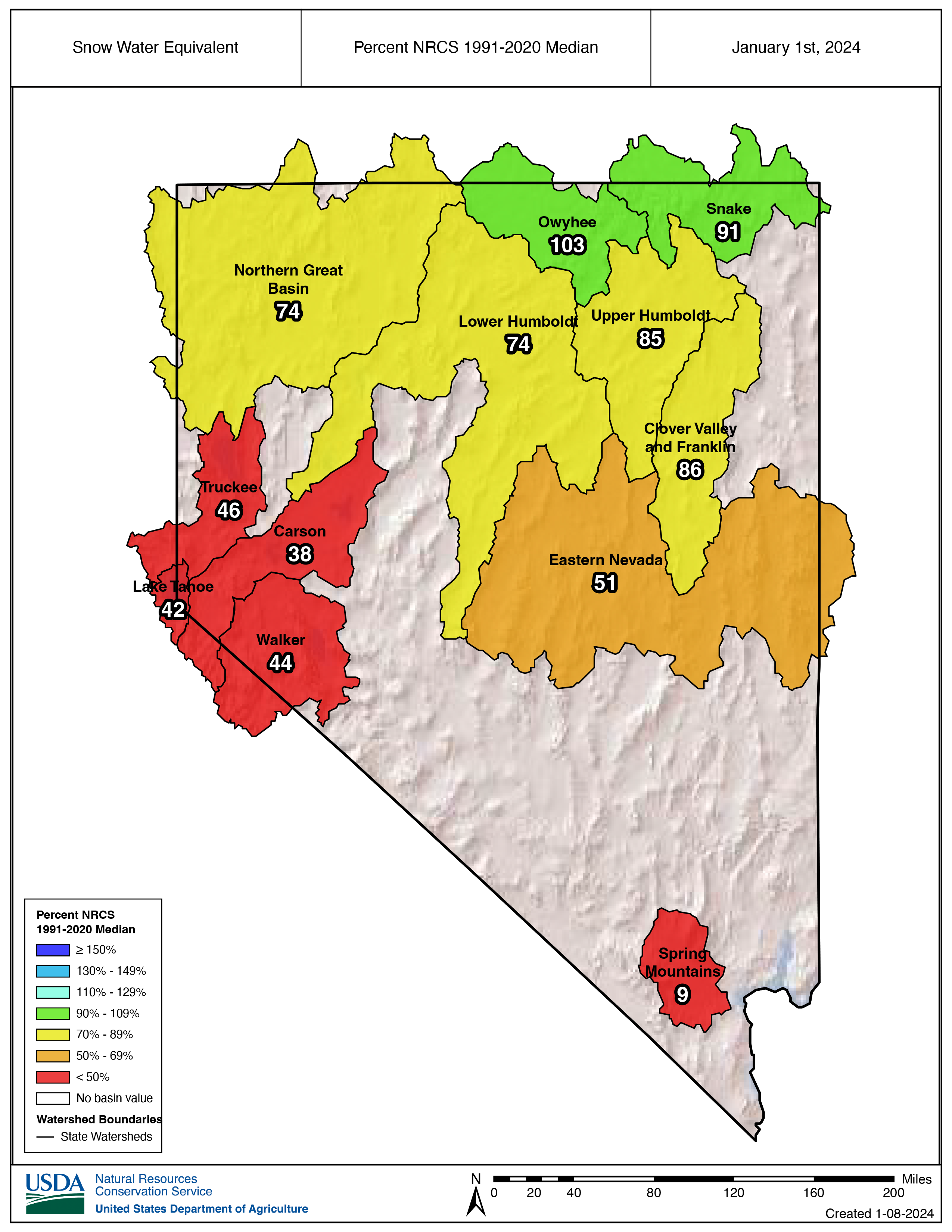
January 1 snowpacks for the Silver State are below normal in almost all areas. Snow is 9% of normal in the Spring Mountains, 38-46% of normal in the Lake Tahoe, Truckee, Carson and Walker basins, 51% in Eastern Nevada and 85% in the Upper Humboldt. The only watershed with a normal snowpack is the Owyhee basin. Below normal snowpacks also exist throughout much of the western United States. Many Snow Telemetry (SNOTEL) weather stations in the Rocky Mountains and Pacific Northwest have record low snowpacks.
As a result of record setting snowpacks in 2023, reservoir storage in northern Nevada is better than this time last year. The April through July streamflow volumes in 2023 set new records for the Carson and Walker rivers. Across the state, strong river flows were enough to meet demand and allow water to be stored in reservoirs.
Due to the low snowpack NRCS January 1 streamflow forecasts are far less than last year. If conditions continue to be dry, the water stored in reservoirs will offer a buffer against drought next summer for water users in basins with reservoir storage. There is still time for the snowpack to turn around, however with each dry week it becomes less likely snowpacks will reach their normal peak snow water amounts by spring.
Access the January 1, 2024, Nevada Water Supply Outlook Report with additional information at the Nevada Snow Survey homepage: https://www.nrcs.usda.gov/nevada/snow-survey
Basin Snowpack and Reservoir Storage Conditions as of January 1, 2024
Lake Tahoe Basin – Snowpack is 42% of median, 6th lowest January 1 snowpack since 1981. Lake Tahoe is storing 507,600 acre-feet of water, which is 68% of capacity. On January 1, 2023, Lake Tahoe storage was 4% of capacity.
Truckee Basin – Snowpack is 46% of median, 6th lowest January 1 snowpack since 1981. Combined reservoir storage in the Truckee Basin is 324,000 acre-feet of water, which is 72% of capacity. On January 1, 2023, reservoir storage was 42% of capacity.
Carson Basin – Snowpack is 38% of median, 7th lowest January 1 snowpack since 1981. Lahontan Reservoir is storing 217,700 acre-feet of water, which is 70% of capacity. On January 1, 2023, Lahontan Reservoir storage was 10% of capacity.
Walker Basin – Snowpack is 44% of median, 7th lowest January 1 snowpack since 1981. Bridgeport Reservoir is storing 35,800 acre-feet of water, which is 84% of capacity compared to 30% on January 1, 2023. Topaz Lake is storing 40,200 acre-feet of water, which is 68% of capacity compared to 24% on January 1, 2023.
Humboldt Basin – The Upper Humboldt snowpack is 85% of median. January 1 snowpack ranks 18th lowest since 1981. Rye Patch Reservoir is storing 67,300 acre-feet of water, which is 35% of capacity. On January 1, 2023, Rye Patch Reservoir storage was 5% of capacity.
Eastern Nevada (Route 50 corridor Austin, Eureka and Ely) – Snowpack is 51% of median. 7th lowest January 1 snowpack since 1981.
Spring Mountains – Snowpack is 9% of median. 4th lowest January 1 snowpack since 2009.
Upper Colorado Basin – Snowpack is 67% of median. 4th lowest January 1 snowpack since 1986. Combined reservoir storage in Lake Mead and Lake Powell is 17.5 million acre-feet of water, which is 35% of capacity. On January 1, 2023, combined reservoir storage was 25% of capacity.
By Jeff Anderson | jeff.anderson@usda.gov | 775-224-3484