 Winter 2023 produced one of the biggest snowpacks ever measured across the Sierra Nevada, the Great Basin and the Colorado basin. The Carson and Walker basin snowpacks broke all-time records based on SNOTEL data back to 1981. Peak amounts were second highest in the Upper Humboldt, Lake Tahoe and Truckee basins, as well as in Eastern Nevada. The Lower Humboldt and Owyhee snowpack ranked third highest. The Upper Colorado Basin’s peak snow water tied 1997 for the best winter since 1986.
Each winter field staff from USDA’s Natural Resources Conservation Service and cooperators from other state and Federal agencies venture out on skis, snowshoes, and snow machines to take readings and maintain equipment at the 85 SNOTEL (Snow Telemetry) weather stations across Nevada and the eastern Sierra. Snowpack, precipitation, air temperature and soil moisture are monitored at the stations and snow surveyors also collect snow tube measurements at an additional 40 snow courses. The data is used by hydrologists at the NRCS National Water and Climate Center to produce seasonal streamflow forecasts for the region’s water managers and water users. Water Supply Outlook Reports are also used by state and Federal agencies, Tribes, individuals, and organizations to make decisions regarding irrigation allocations and agricultural production, fish and wildlife management, municipal and industrial water supply, flood control, power generation and recreation. NRCS provides technical and financial assistance to farmers and ranchers that can assist them with becoming more resilient to extreme weather conditions including droughts and high-water years.
Water Supply Summary
This winter’s record-breaking snow accumulation finally relented in April allowing the snowpack to ripen and begin to melt. Snowpacks reached their maximum water content across Nevada’s basins between April 7-10 with amounts ranging from 169-382% of the normal peak amounts. April’s sunny skies and near record temperatures towards the end of the month ramped up snowmelt allowing a few of the lowest elevation SNOTEL sites across the state to melt out by May 1. By June 1, most NRCS SNOTEL sites below 7,500 feet elevation in the Sierra and below 8,000 feet elevation in Northern Nevada had melted out. As of June 1, significant snow remains at higher elevations and melt will continue into June or July and perhaps even August at the deepest locations.
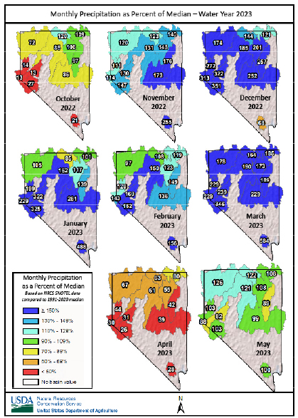
Water year precipitation on June 1 was 112-197% of median across Nevada. Most SNOTELs south of Interstate 80 have recorded October through May precipitation totals that rank above the 80th or 90th percentile compared to historic data.
Reservoir storage will be excellent this summer. In the Truckee Basin, Stampede, Prosser, and Boca reservoirs are all expected to fill once flood control operations are complete. Lake Tahoe’s water level could rise to within a few inches of its legal limit based on current forecasts but may not fill to its legal limit. In the Carson Basin, there is more than enough water to fill Lahontan multiple times. Mangers have drawn Lahontan down and excess water is being released into the desert. In the Walker basin Topaz and Bridgeport reservoirs will also fill once peak flows pass. In the Lower Humboldt Basin, Rye Patch Reservoir should also fill based on streamflow forecasts. In the Owyhee Basin, Wildhorse Reservoir is unlikely to fill based on streamflow forecasts. In the Colorado basin, since the beginning of April Lake Powell has risen over 37 feet and Lake Mead has risen over 8 feet. This is a storage increase of over 2.8 million acre-feet in April and May. The Colorado basin hasn’t seen a snowpack this large since 1997, but it would take a string of similar winters to refill these reservoirs.
Streamflow Forecasts
Nearly all streamflow forecasts for April-July period are more than twice median, and more than a quarter of the forecasts are for more than four times median. The median is the middle value of the 1991-2020 dataset. It represents a volume that is exceeded by half the years. The median is considered more representative of “normal” than the average since the median doesn’t get skewed upward by a handful of large years. A forecast for 300% of median means the total streamflow volume during the April-July period is expected to be three times the median. Spring precipitation will play a big role in where this year’s volume ends up. NRCS streamflow forecasts are intended for water supply planning, they provide a total volume of runoff expected during the spring snowmelt runoff period. Snowmelt has already caused flooding this spring and high flows will continue. The NRCS seasonal forecasts are volumetric and do not provide guidance on peak discharge magnitude or timing. To track flooding potential, use the 5-day forecasts on the NOAA California-Nevada River Forecast Center website (cnrfc.noaa.gov) and click on the stream gage of interest.
Rangeland Conditions
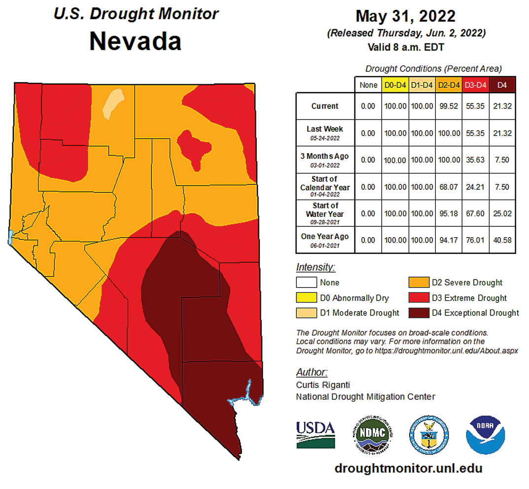
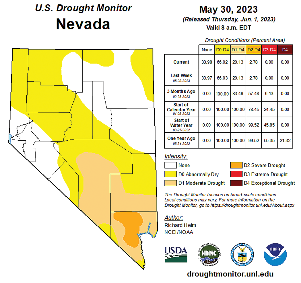
The increase in precipitation this year has improved conditions on the range. As seen below, in 2022, all of Nevada was in the severe to exceptional drought category while this year, approximately 20 percent of the state, mostly in the south, is in any type of drought.
Plant green-up progressed across the state below the snow line. Native wildflowers had an amazing bloom at low to mid-elevations. The native shrub, desert peach (Prunus andersonii) provided a beautiful display of pink flowers in western Nevada. Other early growing shrubs such as bud sagebrush (Picrothamnus desertorum) and spiny hopsage (Grayia spinosa) are also in flower. Native perennial bunchgrasses (needlegrasses, squirreltail, basin wildrye) received much needed winter moisture across Nevada and had a slow start due to colder than normal temperatures. Cheatgrass (Bromus tectorum) set seed at lower elevations where moisture was available across the state and some hillsides stayed green longer than usual. For additional detail about what’s happening with vegetation, the Rangeland Analysis Platform (RAP) provides monitoring and context to evaluate current or past management strategies and develop new ones.
RAP allows producers to visualize and analyze vegetation data and see trends at pasture, ranch, watershed and broader scales. The web-based application can provide a 16-day aboveground biomass production estimate and track changes in bare ground and annual herbaceous, shrub, tree vegetation cover. Other features include assessing fire probability and annual invasive abundance, and comparison of historical imagery of an operation using side by side comparisons sourced from the United State Geological Survey. This link allows you to access the app and view tutorials on how to use the program https://rangelands.app/.
NRCS assistance to increase resiliency of operations
As mentioned earlier, NRCS has a variety of tools available to farmers and ranchers to allow them to adapt to changing climate conditions while supporting their operations. Applications are accepted for all programs year round.
- Conservation Technical Assistance helps to analyzes natural resource concerns on the land and works with producers to develop objectives to address them.
- The Environmental Quality Incentive Program (EQIP) provides financial assistance to address the natural resource issues.
- The Conservation Stewardship Program (CSP) rewards good stewardship of the land.
Over the next three years, there will be an additional $30 million available in EQIP and CSP under the Inflation Reduction Act to help producers adopt practices designed to help them become more resilient to the changing climate.
To find out more about NRCS programs, visit: nrcs.usda.gov/conservation-basics/conservation-by-state/nevada
To find your nearest local NRCS office, visit:
https://offices.sc.egov.usda.gov/locator/app


Figure 1: Matt Cole, NRCS Snow Surveyor from Minden, Nevada, standing above the top of the snow course marker at Willow Flat snow course in the Walker Basin. The April 1 measurement this winter was 425% of median, coming in at 91 inches deep and contained 37.4 inches of water content. This measurement blew away the previous record from 1969 which contained 29 inches of water content. Credit: Jeff Anderson
Figure 2: Willow Flat snow course marker in 2018 when minimal snow existed. Credit: Jeff Anderson
Figure 3: Scott Fennema (left) and Dave Wathen (right) from the Truckee-Carson Water Master’s office after digging out the Ebbetts Pass SNOTEL precipitation gage on March 3, 2023. The gage is 16 feet tall. Credit: Jeff Anderson
Figure 4: A chart showing monthly precipitation as a percent of median during the 2023 snow year, Oct. 2022-May 2023
How to learn more about the snow survey program or request information:
Watch the snow survey video: youtube.com/watch?v=gWm5TeASLY8
Join the Nevada Water Supply Outlook
Report subscription list: nrcs.usda.gov/wps/portal/wcc/home/quicklinks/states/nevada/subscription/
Visit NRCS Nevada Snow Survey web pages to see current conditions:
nrcs.usda.gov/wps/portal/wcc/home/quicklinks/states/nevada/
Request or attend a snowpack and water supply presentation (opportunities noted in Water Supply Outlook Reports)
Request a custom SNOTEL page or data report to meet specific needs
Contact the Nevada Snow Survey at
nrcs.usda.gov/wps/portal/wcc/home/quicklinks/states/nevada/contact/
By Christopher Rose, James Komar and Jeff Anderson
Natural Resource Conservation Service